The Second World War provided a common adversary for both Canada and the United Sates and it forced their political leaders to realize that whatever differences may exist between the two countries sharing North America there should be some way of considering in the broad sense, the defence of the North half of the Western Hemisphere.
In August 1940, Prime Minister Mackenzie-King and President Roosevelt announced the formation of a vehicle of co-operation having just those terms of reference. The Permanent Joint Board on Defence (JJBD) was formalized by Canada in a few days although the US regarded it as an executive agreement and it never went to Senate.
The Board had an American and a Canadian section, each with its own Chairman and a representative from each Armed Service (Army, Navy, Air Force) as well as External Affairs and the State Department. It was the pivotal organization for Canada/United States defence co-operation and had direct ties with the Canadian Cabinet Defence Committee and the United States President as well as collateral ties to the Canadian Chiefs of Staff Committee and the United States Joint Chiefs of Staff.
The accomplishments of this board continue to affect the lives of Canadians even today. Many of them are surprised when presented with even a small list of the PJBDs early projects which included:
Furthermore, the time it took the radio waves to bounce back, and the direction from which they came would give away the location of the enemy planes. This Radio Wave Detection and Ranging (RADAR) technology, then, could be used to provide the early warning (EW) and ground-control intercept (GCI) capability required for a viable air defence system. To protect what were perceived as vulnerable areas during World War II, the USAF deployed some of its first air defence radar stations in the Sault and Newfoundland.
Pinetree Line NOTE: The USAF did not become an independent service until September 18, 1947. During World War II, the US air arm was the US Army Air Forces (formerly US Army Air Corps).
The development of powerful nuclear bombs by the US at the end of the war as well as the transient nature of all military secrets made the development of air defences even more imperative.
As early as 1946, the PJBD was considering a Canada/US Basic Security Plan complete with an extensive network of RADAR stations. The system was so extensive, however, it would have been too costly to run. The RCAF then concentrated its effort only in the Ontario and Quebec areas while the USAF looked after Western and Eastern coverage. By May 1950, the USAF proposed integrating the American and Canadian plans with its own existing network.
A sideline of this development involved the establishment of a Canadian Ground Observer Corps (CGObC). These were people located throughout Canada who were trained to identify low-flying aircraft silhouettes by sight and to report their visual sightings to regional headquarters established to consolidate such reports. The Americans and Britons had equivalent organizations.
The year of 1950 was very busy. The RCAF member, Air Vice Marshall A.L. James and the USAF member, Major General R.L. Walsh met again in July to discuss the RADAR Plan and ensure the homework would be done for the next PJBD meeting in October. Sure enough, the agenda for that meeting had a Long Range Aircraft Warning attachment so that by the next meeting in January 1951, the PJBD could present both governments with their now far-reaching Recommendation 51/1 for the Extension of the Continental Radar Defence System. This was approved by the Canadian Government on 21 February 1951 and by the American President 14 April 1951. It had a target date of 1 July 1952, presumably based on intelligence reports in ACA1-10 that projected 1954 as a date when the USSR would have long-range bombers capable of targeting Canadian and US centres.
Recommendation 51/1 led to the founding of a huge (40 to 50 members) Radar Extension Steering Committee and the signing of Canadian Note Number 454 of 1 August 1951. This note outlined the provisions of the Radar Extension Plan which the committee was now referring to by its American nickname, Project Pine Tree and involved erecting 33 stations on sites (22 more than the original 11 the RCAF had planned - hence the word Extension) located across Canada. The committee was too big to be effective so it ceased to exist after orders established the Pinetree Planning Office (PPO) were signed on 29 May 1951.
Before the ink had dried, however, the USAF was asking for permission to do site surveys for six additional AC&W Squadrons in Canada to improve radar coverage primarily against aircraft flying at low altitudes. These sites were to be temporary and moveable (or M-sites), although this was expanded at the September 1952 meeting of the PJBD to mean that the buildings in which they were to be housed would be of temporary construction and that the radar sites, while not mobile, were transportable. It was possible that they might subsequently be replaced by automatic stations.
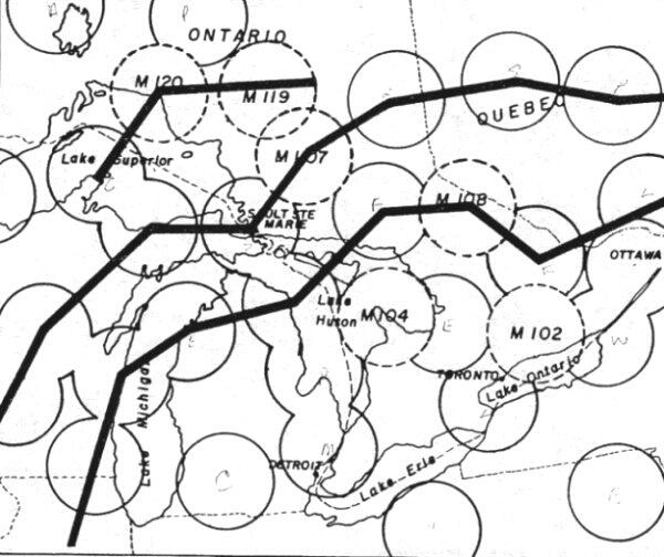
The sites in question were as follows and may be found on the map at the centre of the dotted circles representing their proposed areas of coverage:
Should an enemy bomber be incoming, the outer perimeter would provide EW and track the aircraft into the inner perimeter where (by this time) it would be intercepted. This time and distance in which to conduct a defence is known by military tacticians as depth.
The coverage of todays radars provides sufficient depth that a single site can provide both EW and GCI functions, but the limited range of those early radars was such that this double perimeter concept was needed.
Even so, the radar technology of the time was improving so quickly that the members of the two Air Forces had to be in frequent contact between the PJBD meetings to keep abreast of how the overall system requirements were changing. Air Vice Marshall F.R. Miller had taken over as the RCAF member, and after a working level conference with his counterpart in November, the USAF asked for 3 more mobile radar sites in British Columbia (Birken, Kamloops and Nakusp) at the January 1953 meeting of the PJBD.
In March, the picture changed again. The USAF had obtained practical data on the coverage provided by the new AN/FPS-3 search radars. They had performed better than had been calculated theoretically. Site M-102, which had originally been located at Trenton, Ontario to fill a gap between Watertown, NY and Edgar, Ontario was now deemed no longer necessary. The Canadian External Affairs Department, however, was unaware of this and Canadian Note No. D-85, dated 2 April 1953 granted the USAF permission to carry out a total of nine site surveys.
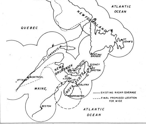
Meanwhile, investigations by the USAF in the radar cover of the East Coast were showing requirement for certain augmentation there. At the April 1953 meeting of the PJBD, (which it must be recalled, represented all three Armed Forces of Army, Navy and Air Forces), it so happened that the US Navy was seeking permission to do a site survey at Sable Island for a sound search station. The Canadian Chairman, General A.G.L. McNaughton, suggested that Sable Island might at the same time be considered as a possible off-shore radar site. It wasnt long before the Navy reached the conclusion that an installation on Sable Island would be extremely difficult and expensive to support logistically. They subsequently transferred their investigation to the Southern tip of Nova Scotia, presumably studying Lockeport, as a possible site until attending a party at which Mr. J.M. Harding (a local barrister who would later be elected into the Provincial Assembly in 1956) suggested they explore Government Point for its suitability. This they did, and the beginnings of what is now CFS Shelburne were quickly landed there.
Similarly, at its June 1953 meeting, the PJBD was informed of the USAFs desire to conduct site surveys in the general vicinity of Cape Sable, Nova Scotia, in lieu of Trenton, Ontario. Furthermore, it was suggested that the construction of these sites come under the cognizance of the PPO, but not under the provisions of Canadian Note No. 454 of 1 August 1951. After some initial procedural objections by Mr. Brooke Claxton, the Defence Minister, the terms for locating the site were settled at a July joint meeting of the PPO.
Canadian Note Number D-227 dated 19 August 1953, authorized surveys around Cape Sable. Local residents recall surveys being done on Cape Sable Island and Baccaro Point. Inasmuch as these surveys usually included moving a small portable radar to the test location. Such activity could not have gone unnoticed.
It is conjectured that local leading citizens and politicians would have favored the Baccaro site since it would bring in more local development (e.g. The road to Baccaro was not yet paved; whereas, the road to Cape Sable Island had just been paved after the opening of the Causeway), although it is unlikely local politicians really played much of a role in the selection. For whatever reasons, by November 1953, the PPO informed the RCAF of the final decision with the following specifics:
Sections 7 and 8 financing and manning, for example, indicated these sites as Group III stations. A particular stations Group depended on who did what. The ten sites financed, constructed and manned by the USAF around Newfoundland or North East Atlantic Command (NEAC) were Group I sites. The sites financed by the USAF but manned by the RCAF belonged to Group II. Group III stations were financed and manned by the USAF, but constructed by the RCAF. Finally, Group IV sites were financed, and manned by the RCAF, regardless of who did construction.
Section 16 was also very interesting in that it conferred upon the foreign personnel serving on these sites the status of NATO Forces.
It remained now to construct the station, fill it with qualified people, and connect it into communications with the rest of the world.